The Oum-Er-Rbia hydraulic basin spreads on a surface of 50.000 km2. The Oum Er Rbia river, of a 550 km length, takes its origin from the Middle Atlas (1800 ms of altitude), cross the Middle Atlas chain, the Tadla plain and the inshore Meseta and throw in the Atlantic ocean at 16 kms far from the city of EL Jadida.
The population of the basin is about 4,5 millions inhabitants, of which 65% are rural. The concentration is more important in centers and the adjacent zones of water courses and sources.
The yearly middle rainfall on the Oum Er Rbia basin is 550 mms, it varies between 1100 mms on the Middle Atlas and 300 mms in the downstream zone of the stream. On average, it snows 20 days/year on the above 800 meters. The temperature varies between 10 and 50°C and the evaporation is 1600 mms per year in average on coasts and 2000 mms inside of the country with a monthly maximum of 300 mms in July and August.
The zone has an economic activity enough varied including the irrigated and no irrigated agriculture, the mining industries, the agro-food industries and of numerous big transformation industries.
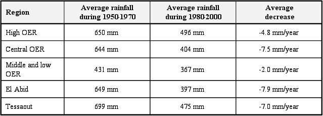
The rainfall decrease in large parts of the basin (High Oum Er Rbia, Central Oum Er Rbia, Low and Middle Oum Er Rbia, El Abid and the Tessaout) is especially significant as shown in the table below.
Rainfall decrease in the Oum Er Rbia Region