Cyprus
Cyprus
Skip Navigation Links
INECO Home page | Cyprus Home Page 

SIGN IN
Login Name:
Login Password:
Remember Name/Password:


Hydrological regions

Following the definitions of the Water Framework Directive, Cyprus has been identified as one River Basin District.

Hydrographically the island is subdivided into 9 hydrological regions, including 70 watersheds and 387 subwatersheds. The area under the control of the Cypriot Government includes 47 watersheds. Cyprus falls within Ecoregion 6 (the Mediterranean sea), on System A, “Ecoregions for transitional and coastal waters, and the Ecoregion 26: Cyprus on System A, “Ecoregions for rivers and lakes” (Republic of Cyprus Law, 13(I)/2004).


The river basin district of Cyprus, including watersheds and rivers


Water crop

The average annual rainfall is about 500 mm, ranging from 300 mm in the central plain and the southeastern parts of the island, up to 1,100 mm at the top of the Troodos mountains. The variation in rainfall is not only regional but also inter-annual and often two and even three-year consecutive droughts are observed. Evapotranspiration is high, and on an annual basis, corresponds to about 80% of precipitation. In general, full irrigation is necessary from late spring to late autumn to sustain production of crops requiring water during this period.

Most rivers originate from the Troodos area. The seasonal distribution of surface runoff follows the seasonal distribution of precipitation, with minimum values during the summer months and maximum values during the winter. As a result of the Eastern Mediterranean climate with long hot summers and a low mean annual precipitation, there are no rivers with perennial flow along their entire length. Most rivers flow 3 to 4 months a year and are dry during the rest of the year. Only the upstream parts of some rivers in the Troodos areas have a continuous flow (rivers of Xeros, Diarizos, Kargotis, Marathasa, Kouris and Germasogeia). Twenty four catchments can be considered of medium size (100 to 1000 km²). All others are classified as small (10 to 100 km²). There are only 5 natural lakes which are brackish or salt. The rest of the surface water bodies are man-made, resulting from river damming or creation of storage basins.

The average annual water crop for this period (1961 – 1990) amounts to 780 hm³. Some 65%, or 510 hm³, of the total annual water crop corresponds to surface runoff. Of the total surface runoff only 45% (230 hm³ or 29% of the total water crop) is lost to sea, a fact that reveals the high level of surface runoff utilization and control achieved in Cyprus over the last 35 years. Of the total sea outflow, a large proportion corresponds to overland flow and flow from minor streams, which cannot be regulated or controlled.


Since 1960, attention was turned to the systematic study and construction of water development works, both for storage and recharge purposes. After a comprehensive survey of the island’s water resources, a long-term plan for the construction of major development projects was followed, involving the construction of a large number of dams. The current total storage capacity of surface reservoirs has reached 307.5 hm³ of water from a mere 6 hm³ in 1960, and will reach 325.5 hm³ with the completion of the Kannaviou dam. This is a truly impressive achievement when compared to other countries of the same size and level of development as Cyprus. The yield of these reservoirs is about 130-150 hm³/yr, however, this value is now seldom reached due to the decline in rainfall and hence in runoff.

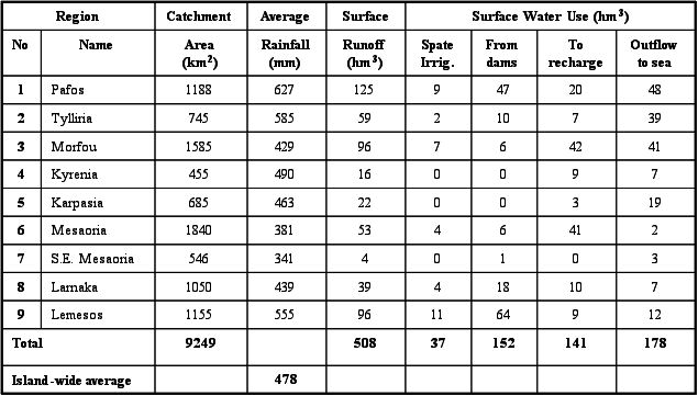
 Surface runoff for each Hydrologic Region

At present, in Cyprus there are 106 dams and ponds: 35 large dams with a capacity of 286.1 hm³ of water, of which 4 are groundwater recharge-flood protection dams, 42 small dams with a capacity of 16.1 hm³ of which 32 are recharge-flood protection dams, and 26 ponds with a capacity of 2.5 hm³. Eighty-one percent (81%) of the dams, i.e. 85 in number, are earth fill or rock fill.

The remaining 19%, i.e. 20 in number, are concrete dams. Generally, these reservoirs are able to hold two to three times the average annual flow of a stream.


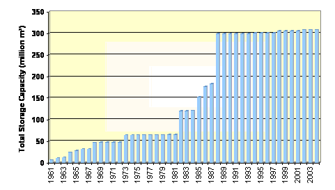
Dam construction (1961 – 2004)