 Cyprus has an intense Mediterranean climate with the typical seasonal rhythm strongly marked with respect to temperature, precipitation and weather in general. Hot dry summers from mid-May to mid-September and rainy, rather changeable, winters from November to mid-March are separated by short autumn and spring seasons of rapid change in weather conditions. At latitude 35° North, Longitude 33° East, Cyprus has a change in day length from 9.8 hours in December to 14.5 hours in June.
The central Troodos massif, rising to 1951 metres a.m.s.l., and to a less extent the long narrow Kyrenia mountain range, with peaks of about 1000 metres a.m.s.l., play an important part in the meteorology of Cyprus. The predominantly clear skies and high sunshine give large seasonal and daily differences between temperatures of the sea and the interior of the island that also cause considerable local effects especially near the coastline.
During the summer, the island is mainly under the influence of a shallow trough of low pressure extending from the great continental depression centered over southwest Asia. It is a season of high temperatures with almost cloudless skies. Precipitation is almost negligible but sometimes isolated thunderstorms give precipitation amounting to less than 5% of the total in the average year.
During the winter Cyprus is near the track of fairly frequent small depressions that cross the Mediterranean Sea from west to east between the continental anticyclone of Eurasia and the generally low-pressure belt of North Africa. These depressions give periods of disturbed weather usually lasting from one to three days and produce most of the annual precipitation. The average precipitation from December to February is about 60% of the annual total.
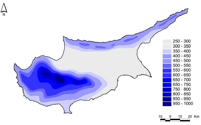
The total yearly average precipitation is about 500 mm (period 1961-1990). A lowest value of 182 mm was observed in 1972/73 and a highest of 759 mm occurred in 1968/69. Statistical analysis of precipitation in Cyprus reveals a drop in the last 30 years. The mean annual precipitation increases up the southwestern windward slopes from 450 mm to nearly 1,100 mm at the top of the central massif of Troodos. On the leeward slopes, precipitation decreases steadily northwards and eastwards to between 300 and 350 mm in the central plain and the flat south eastern parts (the Kokkinochoria area) of the island (Rossel, 2001).