The geomorphology of Cyprus is dominated by two mountain massifs: the Troodos range in the central, southern and western parts of the island, and the Pentadaktylos range which runs in parallel to the northern coastline. Situated between the two mountain ranges is the Mesaoria Plain. The coastline comprises a mixture of low hills, rocky areas, cliffs and narrow plains. Wider plains exist around river estuaries.
The central part of the Troodos Massif (covering approximately 3,500 km² and rising in the west to nearly 2,000 m) consists of igneous rocks (Troodos Ophiolite Complex). The southern and southwestern fringes consist of autochthonous sedimentary rocks.
The central and highest part of the ophiolite complex consists of ultramafic rocks (harzburgites, serpentinites) and plutonic rocks (dunites, wehrlites, pyroxenites, gabbros and plagiogranites). Bordering this is the Sheeted Dyke Complex and, downhill the volcanic rocks (pillow lavas). Autochthonous sedimentary rocks dominate the southern and southwestern periphery with alternating layers of chalks and marls (Lefkara, Pachna and Kalavassos Formations).
The Pentadaktylos Mountain Range has retained its limestone covering over the ages. The two mountain ranges were originally separated by a shallow sea, the bed of which is now the Messaoria (or middle) plain, a fertile agricultural region with the capital city of Nicosia situated at its centre. The highest peak within the Pentadaktylos Mountain Range is Kyparissovouno (1,024 m), followed by Boufavento (955 m) and Gialas (935m). These mountains consist mostly of allochthonous recrystallized limestones, dolomites and marble.
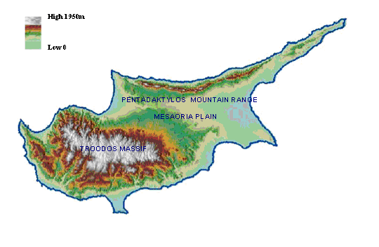
Topography of Cyprus
The Mesaoria Plain (covering 2,500 km²) sits between the two mountain ranges and extends from Morfou Bay to Ammochostos Bay. The topography is dominated by flat or softly undulating areas and scattered, characteristically flat-topped or conical-shaped hills. The altitude reaches up to 300 m. The plain consists mainly of marls, calcarenites, sands and gravels (Lefkosia, Athalassa, Kakkaristra and Apalos Formations) as well as alluvial deposits.