4.
Range of
Circumstances
in Thessaly
The fertile plain of the Thessaly
Water Region covers an area of 13,377 km2 that occupies the central
section of mainland
Among the mountains flows the
Table 12. Surface of the drainage basins in Thessaly
|
Drainage Basin |
Surface (km2) |
|
|
9,500 |
|
|
1,050 |
|
Other Basins |
2,812 |
|
Total |
13,362 |
The climate is Mediterranean continental.
Winters are cold and summers are hot, with a large temperature difference between
the two seasons. The average annual temperature is 16-17oC. The average
annual rain height is 700 mm, ranging from 400 - 600 mm at the central plains
to 600-1,000 mm on the eastern part, and
to over 1,200 mm on the mountains. Rain
fequency is 100-130 days per year. The total precipitation is 10,426 hm3/yr and
the mean annual relative humidity is 67% - 72%. Snowfall is very frequent on
the mountains.

Figure 7. Mean monthly precipitation for the period 1955-1995 in Thessaly

Figure 8. Annual rainfall in Thessaly
Impermeable geological structures cover 39.4%
of the total area; karstic aquifers cover 16.2% and permeable structures, which
occur mainly on the plain, cover 44.4%. The total water availability is about 3,094
hm3, which consists of 2,558 hm3 surface water and 506
hm3 groundwater. The groundwater, which can be found in the karstic
and alluvial aquifers of the region and the entire plain
of mainly Neogene sediments, is replenished by

Figure 9. Monthly average surface natural flow in the
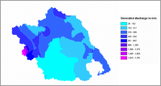
Figure 10. Generated discharge in Thessaly
Monitoring results show that
surface water in
Monitoring results for groundwater show
that in many cases nitrates, and in some cases ammonia,
exceed the critical loads for drinking water. Due
to this, the
The main anthropogenic pressures observed
in
Pollution
trends caused by industrial activities are not significant
as
industrial production is
limited. Pollution loads from industry are most abundant in Larissa and
The main pollutant
loads produced in
·
BOD5: 51,740 ton/yr
·
TSS: 66,670 ton/yr
·
Total nitrogen: 37,920 ton/yr
·
Total phosphorus: 3,750 ton/yr
Irrigated agricultural land occupies 1,894
km2. Water shortage problems are frequent
during the irrigation period, while in the winter floods occur in large areas. The coastal zone is a
favourite destination for many tourists during the summer, increasing water supply
requirements during the tourist period. Areas with the highest water supply requirements are the municipalities of
Larissa and
Water supply in the region is not
regulated by a single authority. The larger cities each have their own water
and wastewater services providers, but there are a number of independent local
services, mostly effected through the municipalities,
and thus, the pricing of water is a subject of political
pressures. Public education for water conservation is limited, and cost recovery
is on average poor with the
exception of the larger cities.
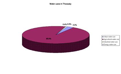
Figure 11. Water uses in Thessaly

Figure 12. Percentage of the total water use in
Table 13.
|
Natural conditions and infrastructure |
Regional Context |
Climate Type |
Mediterranean Continental |
|
Aridity Index |
AI>=0.65 0.2<=AI<0.5 |
||
|
Permanent Population |
753,848 |
||
|
Water availability |
Total Water Resources /Availability (hm3) |
3094 |
|
|
Trans-boundary Water (hm3) |
|
||
|
Water quality |
Quality of surface water |
Good |
|
|
Quality of groundwater |
Average |
||
|
Quality of coastal water |
Poor |
||
|
Water Supply |
Percentage
of supply coming from: v
Groundwater v
Surface water v
Desalination, Recycling v
Importing |
15.7% 68.3% - 16.0% |
|
|
Network
coverage: v
Domestic v
Irrigation v
Sewerage |
45% |
||
|
Economic and Social System |
Water use |
Water
consumption by category: v
Domestic v
Tourism v
Irrigation v
Industrial and energy
production |
3.3% 95.8% 0.9% |
|
Population to resources index |
204 |
||
|
Water demand |
Water
Demand trends |
Stable |
|
|
Consumption
index |
38% |
||
|
Exploitation
index |
31% |
||
|
Pricing system |
Average
household budget for domestic water (pa) |
€ 149 |
|
|
Average
household budget for agricultural water |
|
||
|
Average
household income |
€
10582 |
||
|
Cost
recovery |
Poor |
||
|
Price
elasticity |
Poor |
||
|
Social capacity building |
Public
participation in decisions |
Poor |
|
|
Public
education on water conservation issues |
Average |
||
|
Decision Making Process |
Water Resources
Management |
Water
ownership |
State |
|
Decision
making level (municipal, regional, national) regarding: v
Water supply for each sector v
Water resources allocation
for each sector |
Regional National |
||
|
Water Policy |
Local
economy basis |
Primary sector |
|
|
Development priorities |
Agriculture |
Back Continue to the Range of Circumstances in the Cyclades Islands