5.
Range of
Circumstances
in the Cyclades Islands
The Water Region of the Cyclades
Islands covers an
area of 2,553 km2. The region includes 24 inhabited islands, and is
characterised by fragmentation in several smaller units with differing climatological, hydrological and geomorphological parameters. The islands are semi-mountainous
with small plains and the mean elevation level is 160 m. There are no important
rivers due to the small size of the islands, other than
torrential ones. Surface water is very limited in this
area.
The climate in general is Temperate

Figure 13. Annual rainfall in Naxos Meteorological Station
The geological formations that appear on
the islands vary significantly. Metamorphic rocks cover large part of the
complex; limestone formations are very limited, whereas
volcanic rocks appear on the islands
There are no monitoring results for
surface water quality in
The main
pollution loads
produced in
·
BOD5: 8,000 ton/year
·
TSS: 9,500 ton/year
·
Total nitrogen: 3,400 ton/year
· Total phosphorus: 500 ton/year
The
Table 14. Hydrological Data for the
|
Island |
Surface (km2) |
Precipitation (hm3/yr) |
Evapotraspiration (hm3/yr) |
Total Runoff (hm3/yr) |
Ground Water (hm3/yr) |
|
Amorgos |
121 |
45.9 |
33.89 |
3.81 |
8.10 |
|
Anafi |
38 |
14.4 |
10.66 |
3.64 |
0.10 |
|
|
380 |
144.0 |
104.75 |
25.05 |
2.80 |
|
Antiparos |
35 |
13.3 |
9.77 |
2.43 |
1.00 |
|
Folegandros |
32 |
12.1 |
8.88 |
1.62 |
1.50 |
|
Ios |
108 |
40.9 |
30.27 |
10.39 |
0.24 |
|
Kea |
131 |
49.6 |
36.10 |
9.50 |
0.10 |
|
Kimolos |
36 |
13.6 |
10.06 |
2.24 |
1.30 |
|
Kythnos |
99 |
37.5 |
27.25 |
7.15 |
0.10 |
|
|
151 |
57.2 |
42.33 |
12.47 |
2.40 |
|
|
85 |
32.2 |
23.83 |
8.12 |
0.25 |
|
|
428 |
162.2 |
120.03 |
21.72 |
20.45 |
|
|
195 |
73.9 |
57.76 |
8.34 |
7.90 |
|
Serifos |
73 |
27.7 |
20.50 |
7.10 |
0.10 |
|
Sifnos |
73 |
27.7 |
20.50 |
3.00 |
4.20 |
|
Sikinos |
41 |
15.5 |
11.47 |
3.23 |
0.80 |
|
|
84 |
31.8 |
23.53 |
7.47 |
0.80 |
|
|
76 |
28.8 |
21.31 |
5.69 |
1.80 |
|
|
194 |
73.5 |
53.48 |
13.12 |
1.10 |
In some islands desalination plants are used to cover water demand and in others water is transferred with tankers from the mainland. Several small dams and water tanks have been constructed and are mainly used for irrigation purposes, and others have been planed and approved for construction in the near future.
Water supply in the region is not regulated by a single authority. The larger islands each have their own water and wastewater services providers, but there are a great number of independent local services, mostly effected through the municipalities. Thus, the pricing of water is a subject of political pressures. Public education for water conservation is limited, and cost recovery is overall poor.
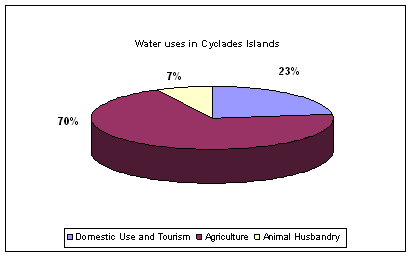
Figure 14. Water uses in Cyclades Islands

Figure 15. Percentage
of the total water use in
Table 15.
|
Natural conditions and infrastructure |
Regional Context |
Climate Type |
|
|
Aridity Index |
0.3- Semi-Arid |
||
|
Permanent Population |
112,615 |
||
|
Water availability |
Total Water Resources / Availability (hm3) |
212 |
|
|
Trans-boundary water |
Yes |
||
|
Water quality |
Quality of surface water |
- |
|
|
Quality of groundwater |
Poor |
||
|
Quality of coastal water |
Good |
||
|
Water Supply |
Percentage of supply coming from: v
Groundwater v
Surface water v
Desalination, Recycling v
Importing |
22.5% 77.5% Yes Yes |
|
|
Network coverage: v
Domestic v
Irrigation v
Sewerage |
|
||
|
Economic and Social System |
Water use |
Water consumption by category: v
Domestic v
Tourism v
Irrigation v
Industrial and energy
production |
9% 14% 77% |
|
Population to resources index |
531 |
||
|
Water demand |
Water Demand trends |
Increasing |
|
|
Consumption index |
50% |
||
|
Exploitation index |
15% |
||
|
Pricing system |
Average household budget for domestic water (pa) |
€ 231 |
|
|
Average household budget for agricultural water |
|
||
|
Average household income |
€
13730 |
||
|
Cost recovery |
Poor |
||
|
Price elasticity |
Poor |
||
|
Social capacity building |
Public participation in decisions |
Poor |
|
|
Public education on water conservation issues |
Average |
||
|
Decision Making Process |
Water Resources
Management |
Water ownership |
State |
|
Decision making level (municipal, regional, national) regarding: v
Water supply for
each sector v
Water resources
allocation for each sector |
Municipal National |
||
|
Water Policy |
Local economy basis |
Tertiary Sector |
|
|
Development priorities |
Tourism |