3.
Range of
Circumstances
in Attica
The Water Region of Attica covers an area
of 3,207 km2. There are several mountains (Parnitha,
Kitheronas, Penteli, Imitos, Egaleo, Pateras) and plains on the coastal zone,
and the mean elevation is 115 m.
The administrative region also includes a few islands, major ones being Egina,
Its two main rivers are Illissos and Kifissos,
which in the urbanized areas have been transformed into covered stormwater
conduits and drain into
Table 9. Surface of the drainage basins in Attica
|
Drainage Basin |
Surface (km2) |
|
|
320 |
|
|
310 |
|
|
185 |
The climate is Mediterranean continental,
and the average temperature is 16 – 18°C. The average annual rain height is 400 mm,
ranging from less than 400 mm in the south coastal areas to 600 mm at the
mainland and 1,000 mm on the mountains. Rain frequency is 50 to 100 days per year.
The precipitation is 1,698 hm3/yr and the total runoff 259 hm3/yr.
Snowfall is very rare at the coastal areas but does occur on the mountains
between
October and April.
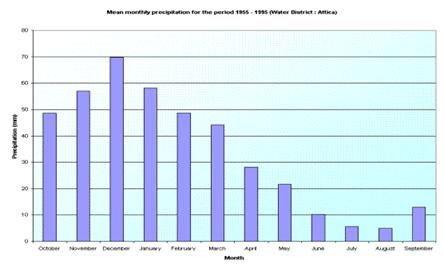
Figure 2. Mean monthly precipitation for the period 1955-1995 in Attica
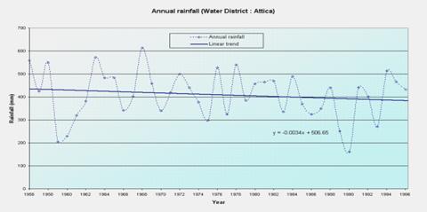
Figure 3. Annual rainfall in Attica
Permeable geological formations cover a significant amount of the total area; karstic limestone formations cover the east and west part of the region. The total water availability is about 449 hm3 and this amount consists of 259 hm3 surface water and 190 hm3 potential groundwater. The groundwater can be found in the karstic and alluvial aquifers of the region.
Table 10. Hydrological Entities of
|
Hydrological
Entities |
Surface (km2) |
Total Runoff (hm3/yr) |
Potential Groundwater (hm3/yr) |
|
Karstic entities in limestone
formations |
|
||
|
|
510 |
157 |
120 |
|
Kitheronas |
260 |
75 |
50 - 70 |
|
Gerania |
250 |
42 |
20 |
|
Penteli |
250 |
55 |
30 |
|
Ymitos |
110 |
15 |
30 |
|
|
300 |
95 |
60 |
|
Total |
439 |
250 - 27022 |
|
|
Alluvial aquifers |
|
||
|
|
440 |
30 |
5 |
|
Mesogeia |
820 |
50 |
15 |
|
|
260 |
15 |
3 |
|
Loutraki |
320 |
20 |
4 |
|
Total |
115 |
27 |
|
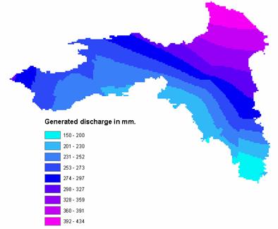
Figure 4. Generated discharge in Attica
There is no systematic monitoring of
surface water quality in
Monitoring results for ground water show that nitrates exceed the critical load for drinking water. In certain areas with significant industrial activity, high concentrations of heavy metals also occur.
The main pollutant
loads produced in
·
BOD5: 120,000 ton/year
·
TSS: 420,000 ton/year
·
Total nitrogen: 20,000 ton/year
·
Total phosphorus: 8,000 ton/year
In order to satisfy the increased demand, a significant amount of water is imported from the Water Region of West Sterea Ellada (Rivers Mornos and Evinos), and also from the Water Region of East Sterea Ellada (Lakes Iliki and Paralimni). Desalination plants are used to cover industrial demand.
The supply of water and wastewater
services is effected by EYDAP
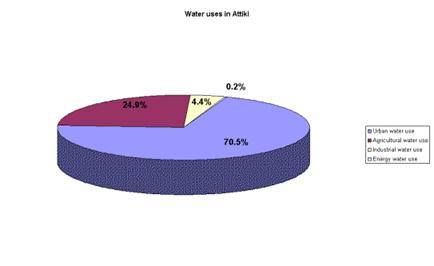
Figure 5. Water uses in Attica
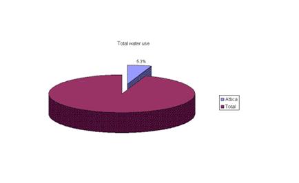
Figure 6. Percentage of the total water use in
Table 11.
|
Natural conditions and
infrastructure |
Regional Context |
Climate Type |
|
|
Aridity Index |
0.31- Semi-Arid |
||
|
Permanent Population |
3,761,810 |
||
|
Water availability |
Total Water Resources /Availability (hm3) |
449 |
|
|
Trans-boundary water |
388 |
||
|
Water quality |
Quality of surface water |
- |
|
|
Quality of groundwater |
Poor |
||
|
Quality of coastal water |
Fair - Poor |
||
|
Water Supply |
Percentage of supply coming from: v
Groundwater v
Surface water v
Desalination, Recycling v Importing23 |
17% - - 83% |
|
|
Network
coverage: v
Domestic v
Irrigation v
Sewerage |
100% - 90% |
||
|
Economic and Social
System |
Water use |
Water
consumption by category: v
Domestic v
Tourism v
Irrigation v
Industrial and energy
production |
71% - 25% 4% |
|
Population
to resources index |
4494 |
||
|
Water demand |
Water
Demand trends |
Decreasing |
|
|
Consumption
index |
69% |
||
|
Exploitation
index |
49% |
||
|
Pricing system |
Average
household budget for domestic water (pa) |
€117 |
|
|
Average
household budget for agricultural water |
|
||
|
Average
household income |
€ 20639 |
||
|
Cost
recovery |
Good |
||
|
Price
elasticity |
Fair |
||
|
Social capacity building |
Public
participation in decisions |
Poor |
|
|
Public
education on water conservation issues |
Fair |
||
|
Decision Making Process |
Water Resources
Management |
Water
ownership |
State |
|
Decision making level (municipal, regional,
national) regarding: v
Water supply for each sector v
Water resources allocation for each sector |
National |
||
|
Water Policy |
Local
economy basis |
Tertiary sector |
|
|
Development priorities |
Urban growth |