
|
Physical Characteristics
| |
|
Geography and Administrative Governorates
|
|
|
|
Egypt lies in the north-eastern corner of the African continent, with a total area of about one million square kilometres. The Egyptian territory is almost rectangular, with a North-South length of approximately 1,073 km and a West-East width of approximately 1,270 km.
Geographically, Egypt is divided into four regions with the following percentage coverage of the country's area:
-
Nile Valley and Delta, including Cairo, El Fayum depression, and Lake Nasser (3.6 %).
-
Western Desert, including the Mediterranean littoral zone and the New Valley (68 %).
-
Eastern Desert, including the Red Sea littoral zone and the high mountains (22 %);
-
Sinai Peninsula, including the littoral zones of Mediterranean, the Gulf of Suez and the Gulf of Aqaba (6.4 %).
The country is divided into 27 administrative Governorates.
|
| |
| |
|
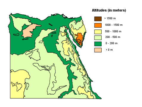 The landscape in Egypt can be broadly divided into the elevated structural plateaus and the low plains (which include the fluviatile and coastal plains). These geomorphologic units play a significant role in determining the hydrogeological framework of Egypt and natural constraints facing population distribution. The structural plateaus constitute the active and semi-active watershed areas. The low plains can contain productive aquifers and are also, in places, areas of groundwater discharge. The landscape in Egypt can be broadly divided into the elevated structural plateaus and the low plains (which include the fluviatile and coastal plains). These geomorphologic units play a significant role in determining the hydrogeological framework of Egypt and natural constraints facing population distribution. The structural plateaus constitute the active and semi-active watershed areas. The low plains can contain productive aquifers and are also, in places, areas of groundwater discharge.
|
| |
| |
|
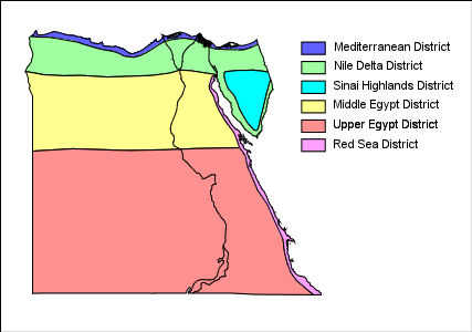 Egypt lies in the dry equatorial region except its northern areas which lay in the moderate warm region with a climate similar to that of the Mediterranean region. Hot dry summers characterizes Egypt’s climate while in the winter it is moderate with limited rain fall that increases at the coast. Egypt can be divided into six climatic districts: Egypt lies in the dry equatorial region except its northern areas which lay in the moderate warm region with a climate similar to that of the Mediterranean region. Hot dry summers characterizes Egypt’s climate while in the winter it is moderate with limited rain fall that increases at the coast. Egypt can be divided into six climatic districts:
-
Mediterranean District: It extends along the Mediterranean Sea with several kilometers to the inside. In summer, the mean temperature is about 23°C while in winter it is 14°C. This district is the most rainy in Egypt (100-190 mm/year).
-
Nile Delta District: It lies to the south of the Mediterranean District. The mean temperatures are 13°C (January) and 27°C (July). In this district, the annual average amount of rainfall decreases sharply to the range of 20 to 50 mm.
-
Sinai Highlands District: It includes the highlands of Sinai. The weather of this district differs from other parts of Sinai in the temperatures and the rainfall amounts. It is colder with a minimum of 10°C difference in temperature. In this district, the rainfall increases and reaches that of the Mediterranean district.
-
Middle Egypt District: It lies between Cairo and Assiut and extends to the western borders of Egypt and to the highlands of the Red Sea in the east. It is the coldest district in winter with hot weather in summer (average 30°C). The annual average amount of rainfall is very little (< 10 mm).
-
Upper Egypt District: It extends from the south of Assiut to the southern borders of Egypt. The rainfall is rare and the difference between the temperatures by day and night reaches 18°C or greater (desert weather).
-
Red Sea District: The region of Red Sea highlands differs climatically from other neighborhood low lands. Therefore, it is more cold and rainy.
Summer temperatures are extremely high, reaching 38°C to 43°C with extremes of 49°C in the southern and western deserts. The northern areas on the Mediterranean coast are much cooler, with 32°C as a maximum. Around April, a hot windstorm called the Khamsin sweeps through Egypt. Its driving winds blow large amounts of sand and dust at high speeds. The khamsin may raise temperatures as much as 38°C in two hours, and the hot winds can damage crops.
|
| |
| |
|
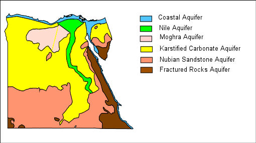 The hydrogeological framework of Egypt comprises six aquifer systems (RIGW, 1993): The hydrogeological framework of Egypt comprises six aquifer systems (RIGW, 1993):
-
The Nile Aquifer System, assigned to the Quaternary and Late Tertiary, occupies the Nile flood plain region (including Cairo) and the desert fringes.
-
The Nubian Sandstone Aquifer System, assigned to the Palaeozoic-Mesozoic, occupies mainly the Western Desert.
-
The Moghra Aquifer System, assigned to the Lower Miocene, occupies mainly the western edge of the Delta.
-
The Coastal Aquifer Systems, assigned to the Quaternary and Late Tertiary, occupy the northern and western coasts.
-
The Karstified Carbonate Aquifer System, assigned to the Eocene and to the Upper Cretaceous, outcrops in the northern part of the Western Desert and along the Nile system.
-
The Fissured and Weathered Hard Rock Aquifer System, assigned to the Pre-Cambrian, outcrops in the Eastern Desert and Sinai.
|
| |
|