Spain
Abstract
Although Spain's water resources related to population, in global terms,
are actually above the Mediterranean, water in Spain can be considered a scarce
resource and extremely vulnerable. This is caused by its unequal spatial
distribution, with excedentary basins and extremely deficitary basins, and by factors such as population growth
and displacement, tourist growth in coastal areas or continuous increase of
irrigation in arid and semiarid areas, which are clearly deficitary.
Competency and management overlapping regarding resource use and re-use,
seriously threaten the policies on water sustainable use that try to start both
at the national and Autonomous Region level. The great biodiversity and water
environment richness is also threatened due to the big local and regional
disarrangement as regards the assignment of water resources.
Among the
different hydrographic regions and deficitary basins, the two cases of the
Canary Islands and of Doñana
and its surroundings have been selected. The Canary Islands show a complete range of risks and
conflict situations within a deficitary territory
with a spectacular tourist growth. Doñana
represents the paradigm of conservation and development, an environment where
population pressure and water table exploitation for new crops has to
conciliate with the conservation of one of the most important wetlands in the
world. The range of circumstances in these two regions is analysed, and
presented in table form.
Introduction
We can say concisely that
there is a strong difference between Northern and North-western areas with
abundant water resources and the dry Southern and Eastern areas. Schematically,
three large sectors can be differentiated, with regard to abundance and
distribution of water resources:
Northern and North-western
sector, including
The Central sector,
constituted by the large inner river basins, shows the pluviometric
shadow by the surrounding mountain systems, receiving little rainfall, with an rise in aridity in the most continental areas (middle
The Mediterranean sector is
constituted by small river basins and average slopes towards the sea. Pluviometry is generally quit low, due to its localisation
in a sector of shadow with regard to the humid North-western winds. To be
emphasised the marked irregularity of precipitations with long drought periods
and catastrophic episodes of convective rainfalls. Scarcity and irregularity is
not compensated by rivers’ contribution, as river basins are quite small in
this sector and with a torrent regime, lacking big water-producers orographic centres. Natural scarcity of water increases
going southwards, reaching its maximum levels in the coastal areas of
The permanent population of
Map 1.
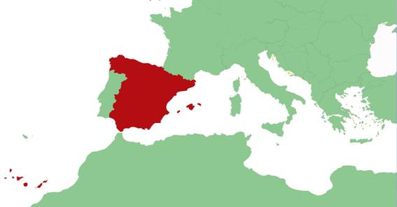
Table 1. Summary of
|
Background |
Description |
|
Climate |
The main characteristic of The Northern part is
characterised by a mild climate, with storms of Atlantic origin that are
practically present all the year round, giving rise to a high relative
humidity and mild temperatures, temperate in winter and cool in summer. In
the Mediterranean coast and part of inner Climate is generally dry in the Canary Islands
(especially in the eastern islands, as the western ones are influenced by
Atlantic air masses charged with humidity) and in the coastal area of Murcia
and Almeria, where only scarce precipitations
occur. In accordance with the humidity UNESCO’s Global Humidity
Index, based on a ratio of annual precipitation and potential evapo-transpiration (P/PET) index, ·
Arid areas: Eastern mainland sector,
eastern-southern areas of the ·
Semi-arid areas: ·
Sub-humid: ·
Humid: |
|
Geology |
One of the most relevant
features of Spanish mainland is its central plateau, flat lands with average
altitude of 600 m above the sea level that occupy nearly half of the Spanish
area. It is vertebrated by the Central Cordillera,
characterised by granitic and shale formations. The
origin of the plateau lies in the existence of two depressions of the
basement that were filled by hundreds of metres of clay-loamy and gypsiferous sediments coming from the adjacent mountain
chains. There are other two outstanding deep depressions ( |
|
Geomorphology |
|
|
Soils |
According with the Soil
Taxonomy classification, in |
|
Surface water |
The little river
flow reveals the scarce pluviometry within the
hydrographical network. Big collectors are divided in those coming from the
central plateau ( In |
|
Water storage features |
Dam capacity is at present
of 53,191 hm3 (INE 2001). This quantity is one of the highest dam
index ratio in A good percentage of these is
constituted by dams with hydroelectric capacity: Maximum capacity of
hydroelectric dams is 18,047 million kWh (UNESA, 1997). |
Map 2: Climatic
classification according with the UNESCO’s humidity index

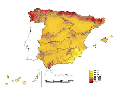
Map 3.: Precipitations
in

Map 4.:Actual yearly average evapo-transpiration
Overview
of the country
Water Demand and Supply Status
Urban water supply
This demand encloses the one
originated in population centres, both to satisfy domestic consumption and
linked to other activities, can be industrial or service-related. It sums up to
some 4,700 hm3 /year.
Coastal concentration of population specially affect
the Mediterranean area, with in a process tending to coastal conurbation. The
important tourist development of these regions, which in many cases is the main
economic activity, sums to this demographic distribution feature and water
spatial demand. Tourist activities produce an approximate yearly increase of
10% in the population demand, although the increase is higher due to the high
consumption of several recreational activities. This increase is very
concentrated in time, more precisely in the summer period, which have bigger supply problems.
Forecasts made by the basin hydrological plans suggest increases of 15%
and 36% on the present situation, in 10 and 20 years respectively. The
draught periods of the last decade have shown the serious risks of lack of
supply in large regions.
As regards sewerage, the percentage of purified urban waste water is
around 60%, although only 45% meets the requirements of Directive 91/271.
Industry
Yearly water quantity dedicated to industry use in
Irrigation
Quantitatively speaking, irrigation is the main use of water in
Environmental requirements
Conservation of ecological and
landscape resources linked with water requires maintaining minimum flows: water
table discharges, river flow-level or quantity of water reaching the sea at the
river mouth, without which these resources can suffer a strong degradation. In
the Mediterranean area and in the south there is a clear concentration of the
risk of scarcity, and this situation corresponds to the natural scarce
availability of water resources and to the high concentration of demands that
concern all water uses: agriculture, tourism, industry and population supply.
Scarcity in deficitary areas had as a first
effect an accused tendency towards over-exploitation of ground water, above its
natural renewal ratio. In the actual
case of ground water, exploitation is at present around 5,500 hm3
per year, that cover 30% of urban and industrial supply and 27% of the
irrigated area. Excessive exploitation of surface water
resources sums up to the impacts produced by ground water overexploitation. This policy brought to the present situation where
Map 5. Density
and distribution of the population.
The effect on the deficit areas.
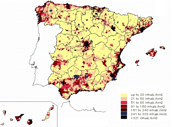
Table 2. Available
Surface Water Resources in the 13 water regions.
|
Water
Availability (hm3) |
A
1967 |
B 1980 |
C 1990 |
D 1991 |
E 1993 |
F 1998 |
|
Coastal Galicia |
- |
- |
- |
1302 |
1302 |
- |
|
North |
8525 |
7448 |
- |
4967 |
8828 |
- |
|
Duero |
6405 |
9111 |
9465 |
9269 |
7797 |
10229 |
|
Tajo |
4356 |
8343 |
6281 |
6233 |
6233 |
5063 |
|
Guadiana |
2252 |
2462 |
3017 |
2385 |
2963 |
2963 |
|
Guadalquivir |
3564 |
2810 |
4780 |
3255 |
3416 |
3451 |
|
South |
538 |
785 |
533 |
861 |
1109 |
1007 |
|
Segura |
665 |
1317 |
1742 |
700 |
1125 |
1500 |
|
Júcar |
1850 |
3104 |
2003 |
2564 |
3052 |
3437 |
|
Ebro |
8502 |
14133 |
9289 |
9337 |
10727 |
9898 |
|
C.I. Catalonia |
697 |
1656 |
- |
1358 |
1358 |
1587 |
|
|
- |
313 |
- |
312 |
312 |
300 |
|
- |
496 |
- |
496 |
420 |
417 |
a)
Water Resources. II
Social and Economic Development Plan. Presidency of the Government, PG (1967).
b)
National Hydrologic
Planning. Inter-Ministry Commission of Hydrological Planning. MOPU-CIPH (1980).
c)
Hydrologic Plan.
MOPU-DGOH (1990).These data only refer to river basins involving more than one
Autonomous Region.
d)
Water in
e)
PHN Report. MOPT
(1993). It includes over-exploited water tables:
f)
River Basin
Hydrologic Plans (1998).
Table 3. Available
Groundwater Resources in the 13 water regions. Deficits of water
balance.
|
Water
Availability (Hm3) |
Natural reloading
|
Pumping Hm3/year |
% Pumping/Reloading |
% Pumping/total |
Deficit (1) p/r > 1 |
|
Coastal Galicia |
2234 |
- |
- |
- |
- |
|
North |
8716 |
52 |
- |
- |
- |
|
Duero |
3000 |
371 |
12.4 |
6.7 |
- |
|
Tajo |
2393 |
164 |
6.9 |
3.0 |
- |
|
Guadiana |
750 |
814 |
110 |
14.7 |
240 |
|
Guadalquivir |
2343 |
507 |
21.6 |
9.2 |
10 |
|
South |
680 |
420 |
61.8 |
7.6 |
68 |
|
Segura |
588 |
478 |
81.2 |
8.6 |
215 |
|
Júcar |
2492 |
1425 |
57.2 |
25.8 |
54 |
|
Ebro |
4614 |
198 |
4.3 |
3.6 |
- |
|
C.I. Catalonia |
909 |
424 |
46.6 |
7.7 |
10 |
|
|
508 |
284 |
55.9 |
5.1 |
14 |
|
|
681 |
395 |
58.0 |
7.1 |
32 |
1. Deficit of exploitation units in relation with pumping/reloading >
1
Ratio pumping/reloading Ratio
pumping/total pumping in
Figure 1. Distribution of consumptions

Table 4. Water
consumption in the 13 Water regions.
|
Water Consumtion (hm3) |
Domestic Use |
Industry |
Irrigation |
Refriger. |
Total |
Consumo |
Retorno |
|
Coastal Galicia |
210 |
53 |
532 |
24 |
819 |
479 |
340 |
|
North |
550 |
527 |
532 |
73 |
1692 |
646 |
1046 |
|
Duero |
214 |
10 |
3603 |
33 |
3860 |
2929 |
931 |
|
Tajo |
768 |
25 |
1875 |
1397 |
4065 |
1728 |
2337 |
|
Guadiana |
157 |
84 |
2285 |
5 |
2531 |
2877 |
654 |
|
Guadalquivir |
532 |
88 |
3140 |
0 |
3760 |
2636 |
1124 |
|
South |
248 |
32 |
1070 |
0 |
1350 |
912 |
438 |
|
Segura |
172 |
23 |
1639 |
0 |
1834 |
1350 |
484 |
|
Júcar |
563 |
80 |
2284 |
35 |
2962 |
1958 |
1004 |
|
Ebro |
313 |
415 |
6310 |
3340 |
10378 |
5361 |
5017 |
|
C.I. Catalonia |
682 |
296 |
371 |
8 |
1357 |
493 |
864 |
|
|
95 |
4 |
189 |
0 |
288 |
171 |
117 |
|
|
153 |
10 |
264 |
0 |
427 |
244 |
183 |
Map 6. The Hydrologic basins of
Environment and Protection
Groundwater over-exploitation is among the most relevant environmental
effects of water use in
Risks can be better appreciated in the Eastern Spanish regions, in the
Mediterranean area and the islands (especially the
The situation of subterranean resources has an important repercussion on
surface waters, as it brings to spring , lowering of
basic levels of river flow, reduction of inland wetlands and coast salinisation. The exhaustive exploitation
of surface water resources sums up to the impacts produced by over-exploitation
of ground waters. We have in fact regulation percentages higher than 70
% for the
Spread contamination coming from agriculture, connected to the
increasing use of fertilisers and other chemical like insecticides, is another
worrying danger for
As regards waste water and purification, in spite of the big effort in
infrastructures, it has not been possible to stop degradation of water quality, that affects both human consumption and natural
areas linked to water (wetlands, river borders, etc.). As a reference it is
noteworthy that 60% of water from Spanish rivers is not apt for human
consumption.
To control water quality,
The most affected natural areas, landscapes and ecosystems of interest,
especially those included in the Natura 2000 network,
correspond to:
·
Riverine ecosystems,
especially those located in the Mediterranean areas, which are seriously
threatened.
·
Continental wetlands and lake systems, subjected to
strong impacts caused by water-tables over-exploitation or surface water
depletion.
·
Small wetlands linked to ground water.
·
Lands traditional submitted to irrigation, whose
abandon involves the loss of an important landscape and cultural heritage of
the Mediterranean region, which in several cases also host habitats or species
of regional. national or communitarian importance.
The following table shows the main significant effects linked to water
deficit caused by over-exploitation:
Table 5. Environmental effects
associated with water deficit and water-table overexploitation
|
ECOLOGICAL AND
PUBLIC-USE REPERCUSSIONS |
HYDROLOGICAL EFFECTS
|
|||||
|
Water-table
overexploitation |
Marine Intrusion |
Deterioration of
water quality in water tables |
Reduction of
river contributions |
Deterioration of
surface water quality |
|
|
|
Subsidence
processes |
|
|
|
|
|
|
|
Soil
salinisation |
|
|
|
|
|
|
|
Eutrophication of masses of water |
|
|
|
|
|
|
|
Alteration of coastal ecosystems |
|
|
|
|
|
|
|
Degradation of wetlands (e.g. Daimiel – Doñana) |
|
|
|
|
|
|
|
Degradation of riverine ecosystems |
|
|
|
|
|
|
|
Loss of biodiversity - water species of animal and plants |
|
|
|
|
|
|
|
Alteration of riparian communities |
|
|
|
|
|
|
|
Degradation of agricultural traditional landscapes |
|
|
|
|
|
|
|
Health-Sanitary risks linked to public river-beds |
|
|
|
|
|
|
|
Loss of recreational resources linked to water |
|
|
|
|
|
|
|
Loss of landscapes |
|
|
|
|
|
|
|
Critical effects |
|
|
Serious effects |
|
|
Moderate effects |
|
Water laws and Regulations
With regard to competencies in the field of water, in the Spanish case
we must take into account the complementary, and
sometimes decisive role of the Autonomous regions. Article 149.1.22 of the
Spanish Constitution attributes the State the exclusive competency in the
subject of legislation, planning and concession of resources and water
exploitation when they flow through more than one Autonomous Region. On the
contrary, according with the article 148.1.10, Autonomous Communities can have
competencies on water exploitation projects and construction, and irrigation
channels of interest within their territory. Most Autonomous regions have been
transferred these competencies, which also include subterranean waters.
The Water Law (Ley de Aguas
- 29/1985), is the State’s basic text that regulates
this subject, and only regulates the State’s competencies. Nevertheless, the
exercise of these competencies has to be ruled by the delimitation criterion
used by the Water Law, based on the “river basin” concept, being the
interregional river basins of exclusive competency of the State, with few
exceptions. Law 9/1992, December 23rd, regulates the transfer of
competencies to Autonomous regions. The Water Law disposes that Basin
Administration bodies have to be created for hydrographical basins exceeding
the Autonomous Regions’ territory. These Basin Administration bodies will be
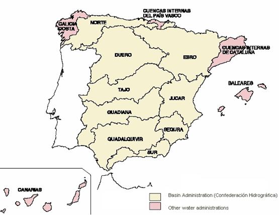
the State’s bodies with competencies on this issue. In
Within this framework, one singularity is the “
The hydrological planning has also the Law rank (Law
10/2001-Hydrological National Plan), and organises a large part of competencies
and functions within the water management scope.
Beside the Water Law, and among a large variety of regulations related
with the use of water, the following ones are worth emphasizing:
·
Water resources for domestic use: Royal Decree
1138/1990: Health-Technical regulation for the supply and quality control of
potable water for public consumption.
·
Regulation of municipal competency with regard to
potable water supply to population, including sewerage (beside the articles of
the Water Law): Basis Laws of the Local Administration.
·
Regulation of the Water Public Domain (R.D. 849/1986, April 11th).
·
Standards to measure the quality of water, including
water contamination by persistent organic pollutants are contained in the Royal
Decree 927/1988.
·
Royal Decree 261/1996, February 16th, on
the protection of water against the contamination produced by effluents from
agricultural sources.
·
Energy aspects related to water are regulated by the
R. D. 2818/1998, about electric power produced by plants powered by renewable
energy sources, waste or cogeneration.
·
Royal Decree (Ley 9/2000) on
Envirronmental Impact Evaluation (including trasvases of but of 100 hm3 /year).
As regards water resource protection, it is integrated by an extensive
legislative repertory referring to the protection of the environment and of
habitats declared protected areas or of community’s interest. The several
national laws (in particular Law 4/1989 about conservation of natural areas and
of wild flora and fauna), are complemented by autonomous regions’ laws, and in
both cases specific regulations on water in protected areas are included.
Special attention is given to forest areas that are providers of water resources,
wetlands (especially SBPZ and RAMSAR sites) and to those sections of rivers
that host a high biodiversity. The Legal
Order attends to and is especially complemented by the Directive 92/43/EEC
regarding conservation of natural habitats and wild flora and fauna, as well as
the Directive 79/409/EEC, relative to wild bird conservation.
Most EC’s directives have been transposed the related legal order, both
with regard to water protection and public health. As an example, there are
more than 20 EC Directives, incorporated to the Spanish legal order regarding
quality requirements of water in function of its use.
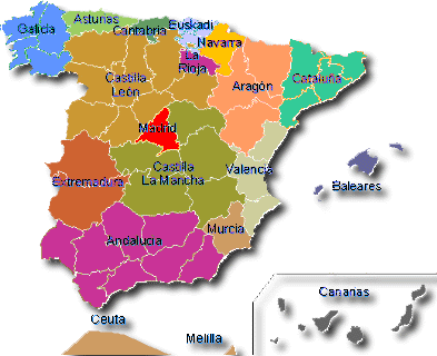
Map 7. Autonomus Regions in
Institutional framework and constraints
The institutional and competency framework of hydrological planning and
water use is structured on the base of the two following instruments:
• The National Hydrological
Plan.
• The Hydrological Plans of
each basin.
The
The National Hydrological Plan, approved by law (Law 10/2001) defines
the competency areas and the water management framework in
The management at the level of each hydrographic
basin is assigned to the already mentioned Basin Administrations, whose
functions are collected within art. 21 of the Law, and are the following:
·
The elaboration of the Basin Hydrological Plan, its
following-up and revision.
·
The administration and control of the public water
domain.
·
The administration and control of the exploitations of
general interest or that affect more than one Autonomous Region.
·
Planning, construction and exploitation of all works
carried out with charge to the own funds of the Administration and those that
have been assigned to them by the State.
·
Those deriving from agreements made with the
Autonomous Regions, Local Administrations and other public or private bodies,
or those signed with privates.
The competency survey closes with the Users' Communities, registered at
the Basin Administration, among which the irrigators' Communities stand out for
their importance. On the other hand, the State Water Society have been created for the
promotion of the hydraulic infrastructures included within the Basin
Hydrological Plans. Their objective is to facilitate the joint intervention of
private and public initiative for the execution and exploitation of the works
carried out in each basin and, in definitive, to optimise the available
economic resources.
One of the characteristics of the institutional conflicts is found in
the disparity of criteria between the Ministry of Agriculture and the Ministry
of the Environment when it is time to elaborate the Basin Plans. An almost
permanent disagreement that rises from the contradiction that who decides water
agricultural uses is not the final responsible for them. A significant example
is given by the clear disconnection between the National Hydrological Plan and
the National Irrigation Plan, presented by the Ministry of Agriculture but not
approved, that plans 250,000 ha of new irrigated lands, while the Basin Hydrological
Plans forecast a total of 1,500,000 ha. On the other hand the viability of new
irrigated lands is not so clear, and it should be questioned to consider them
as the main, or only way of rural development.
Municipalities have competency for potable water supply to the
population and for sewerage. To carry out these services, local bodies can use
the type of management allowed by articles 57, 85 and 87 of the Law of Bases
for the Local Regime. Therefore it can be chosen between a direct management
(by the Local Administration itself, its Autonomous bodies or commercial
societies with exclusive capital), or an indirect management (commercial
societies with majoritarian capital, concessions and
agreements).
It is within Municipal supply that the extreme overlapping and
atomisation of competencies is shown in the clearest and most negative way. The
Administration's uncontrol of the concessionaire
companies' functioning is very high, in a framework where most supply services
with a public management are being transferred to private companies (it does
not exist a national regulation. It is worth reminding that he
process of privatisation is not subjected to any control and in most occasion
it is used to correct deficits, of various origin, of the municipal budgets.
Competency and institutional
overlapping is also shown in cases such as low efficiency of the
purification plants given to municipalities, most of which are unoperational or abandoned after they have been entrusted
to municipalities.
Low bill collecting efficiency sums up to the competency dispersion of
the institutional framework. It is due not only to the same concept of the
economic-financial regime, but also to the low efficiency of the system to
collect exactions (collection is situated around 50% of total billing and in
many cases considerable delays take place). Furthermore, 75% of the water
consumed in
Table 6. Responsible Authorities in
the Water Sector
|
Responsibilities |
Agency/Authority |
|
Planning Regulations |
Ministry of Environment Water National Council
(Consultative) Basin Administrations (Conferederaciones Hidrográficas) Autonomous Regions (A.R.) |
|
Administration and control
of the hydraulic public dominion. |
Basin Administrations
(Confederaciones Hidrográficas) Autonomous Regions (internal
river basins) |
|
Domestic and urban |
Ministry of Environment Ministry of Industry Ministry of Health and Consumption. Basin Administrations Civil Works Administration (A.R) Health Administration (A.R.) Industry Administration (A.R.) Environment Administration (A.R.) Diputaciones Provinciales. Minicipalities as final administration in
charge |
|
Irrigation |
Ministry of Agriculture Ministry of Environment Autonomous Regions Comunidades de
Regantes |
|
Infrastructures |
Ministry of Environment Basin Administrations
(Confederaciones Hidrográficas) State Water Society Autonomous Regions |
|
Purificatin and Re-use |
Ministry of Environment Ministry of Development Ministry of Health and Consumption. Basin Administrations Civil Works Administration (A.R) Health Administration (A.R.) Environment Administration (A.R.) Diputaciones Provinciales. Minicipalities as final administration in
charge |
|
Hydroelectric uses |
Ministry of Environment Ministry of Industry and Energy Basin Administrations Autonomous Regions |
Management, Institutional and policy options
Spanish water policy is found
in the National Hydrological Plan, in the Basin Hydrological Plans and, complemantarily, in the policies and decisions developed at
the level of each Autonomous Region.
The strategic options set forth in the National Hydrological Plan can be
summarised as follows:
Programmed
reduction of demand.
·
Maintenance of present-day water contribution by
inter-basin transfers.
·
Increase in available volumes through a major use of
waste water and modernisation of irrigated lands.
·
Adoption of measures of saving and modernisation of
irrigated lands.
·
Programmed withdrawal, by public initiative, of the
irrigated lands supplied through overexploited water tables which are
unsustainable on the medium-long term.
·
Application of compensatory measures to the affected
collectives.
·
Priority maintenance of water domestic supply.
·
Reduction of losses during water transportation (there
are limit situations that at present are around 50% in large trasvases).
Large-scale
desalination. Covering deficits through large-scale desalination of seawater
complemented by saving and re-use measures:
·
Applications of the measures considered in the
previous option, except the reduction of irrigated lands, incorporating an
additional water contribution from seawater desalination.
·
Maintenance of consumption levels similar to the
present ones, only increased by the new demands of supply.
·
Effective control of the agricultural demand increase
through legal and technical-administrative instruments.
Inter-river basin transfers. Covering deficits
through water transfer from other basins, according with the existing
possibilities, complemented by desalination, saving and re-use measures:
·
Stabilisation of agricultural demand, maintaining
irrigated land area at the same level corresponding to the present-day
situation, through application of legal and technical-administrative
instruments.
·
Adoption of water saving and re-use complementary
measures similar to those contemplated in the previous options.
·
Local seawater desalination for local supply.
·
Inter-basin transfer are
planned following the criterion of minimising both water costs and
environmental effects on the affected river sections and the territories that
host the water-transportation infrastructures.
This last option has generated
the strongest social tensions and environmental contestations between the
different basins. It is worth reminding that the National Hydrological Plan
states in its prologue that “inter-basin transfers should constitute the last
solution".
Beside the multiple
initiatives at the Autonomous regions level, at the State level there is a
group of Programmes and action lines that exemplify the options of future with
regard to water policy and management. We have therefore:
·
The Programme for the improvement and modernisation of
traditionally irrigated lands, whose aim is irrigating water saving,
improvement of water quality, re-use of waste waters and energy saving.
·
As regards sewerage, there is a National Plan of
Sewerage and Waste Water Purification, through which infrastructures for
sewerage and waste water purification are planned, with the aim to achieve by
2005 that urban settlements of more than 2,000 inhabitants will rely on
adequate purification systems. Nevertheless, municipal wastes sum up to 3.500 hm3/year approximately, of which more than 700
are directed to the sea. In these moment re-use of
waste water is close to 100-150 hm3/year, and constitute one of the most
delicate points to resolve as regards sustainable management of water resources,
due to the high degree of competency disorder.
Furthermore a number of
awareness promotion campaigns on sustainable use of water have been carried
out, although their repercussion at a national level is of little significance.
On this line it is necessary to include the impact of the new municipal,
large-reaching initiatives such as the implementation of local Agendas 21, that
include programmed
improvements regarding water sustainable use and water quality.
Map 8. Distribution
of the irrigated land. Water source.

Map 9. Distribution
of the water deficit (all concepts).
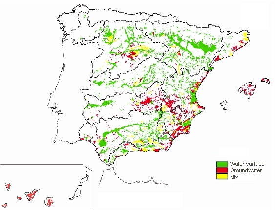
Table 7. Constraints facing the water
sector
|
Category |
Constraints |
|
Natural |
Unequal water spatial
distribution. Uneven precipitation
distribution, spatially and temporally. Dependence on transboundary waters. High sensitivity and risk of
loss of the aquatic ecosystems. Frequent droughts. |
|
Human |
Tendency - distribution of
population towards deficit areas. Tourist influx is uneven in
space and time. Excessive water consumption
for irrigation. Demand peaks in the dry
season. Groundwater and surface
water is contaminated by pollutants. Spread contamination coming
from agriculture. Overexploitation of
underground aquifers. Irrigation of unsuitable or nonprofitable cultures. Lack of environmental
awareness. |
|
Technical |
Technological incapacity of
the local authorities and particularly maintenance of water infrastructure. Old distribution networks
with high losses (average 50 years) Complexity of transvases. Lack of proper irrigation
techniques that would save water. Low efficiency of the
purification systems. Little technological diversification. Illegal connections to the
networks. Absence of control (60% of
water not entered). Use of conventional energy
sources for the massive desalination. Lack of information on new
technologies for water saving and management |
|
Financial |
Water pricing is politically
influenced and not based on water cost, leading to inadequate finances for the
funding of further infrastructure. Inadequate prices for final
uses in sectors like the tourism and the new cultures - competition with
other traditional sectors. Deficient allocation of
funds to the remote regions. Serious difficulties for the
application and collection of the “spill canon”. Noninclusion of environmental
externalities. Destiny of the financial
collection for aims different from the water. |
|
Administrative and Institutional |
Overlapping and atomisation
of competencies (e.g. urban supply). Lack of coordination among
responsible authorities. Lack of participation of key
water actors in the Basin Administrations. Undefinition of the roll of
the Users Communities. Lack of convergence of the sectorial
policies. Absence of homogenous criteria in the privatization
processes. Lack of citizen
participation. |
Table
8. Water
Resources Planning Matrix
Activity
|
Municipal Authority/ Water
Utility |
Autonomous Regions |
River basin authorities |
Users Communitiess |
Ministry of Environment |
Ministry of Agriculture |
Ministry of Industry |
Surface
water
Use Storage Recharge Diversion Quality monitoring Assessment |
X X X |
X X X X X X |
X X X X X X |
X X |
X X X X X |
X X X |
X X X X |
Ground
water
Use Storage Recharge Quality monitoring Assessment Well/drill permits |
X X X |
X X X X X X |
X X X X X |
X X |
X X X X X |
X X X |
X |
Irrigation
network
Rehabilitation Modernization |
|
X X |
X X |
X X |
X X |
X X |
|
Reuse
Drainage water Wastewater |
X |
X |
X X |
|
X X |
X |
|
Desalination
|
X |
X |
|
X |
X |
|
|
|
Introduction
of technology |
|
X |
X |
|
X |
|
X |
|
Efficient water utilization Domestic Industrial Irrigation |
X |
X X X |
X |
X |
X X X |
X |
X |
Legislation
Regulation and codes Standards |
X |
X X |
|
|
X X |
X X |
X X |
Policy setting
|
|
|
|
|
X |
|
|
|
Water
allocation |
X |
X |
X |
|
X |
|
|
|
Project
financing |
|
X |
X |
X |
X |
X |
X |
|
Project
design |
|
X |
X |
|
X |
|
|
|
Project
Implementation |
|
X |
X |
X |
|
X |
|
|
Operation
and maintenance |
X |
X |
X |
X |
|
|
|
|
Pricing
|
X |
X |
X |
|
X |
|
X |
|
Enforcement
|
|
|
|
|
|
|
|
|
Water
Data records |
X |
|
X |
|
X |
X |
|
Selection of
Representative Regions
Among the areas and regions affected by water resource deficiency, which
fall within the arid and semiarid areas scope, two spaces have been selected,
in view of their representative social, environmental and economic features.
Map 10. Selected
regions.

1.
The
Map 11.

2.
Doñana, region and connected hydrographic
basins. The wide region of Doñana and its
surroundings represents at present an authentic paradigm as regards water resource
management, planning and assignment. It hosts the most important wetland of
Europe, the Doñana National Park (Ramsar and World Heritage site), but at the same time its
surroundings host a population of more than 100,000 inhabitants, whose activities
(fundamentally recently introduced agriculture) progressively clashes with the
requirements needed to maintain the seasonal water levels for the wetland
conservation. The programme Doñana 2005 and
the Sustainable Development Plans of the Doñana
surroundings try to face the dilemma between conservation and development in a
framework of water scarcity and progressive alteration of water tables in an
area where quality of water, both for human consumption and for the
conservation of basic ecosystems, is a serious problem.
Figure 2. Orthophoto of the Doñana region.

Due to their geographic localisation, close to the Tropic of Cancer, the
In spite of that, the Canaries are poor in freshwater resources. The
extent of their own freshwater resources, 177 m3 per inhabitant per
year, place them in the last place within the Spain classification by
hydrographical river basins, and this number is very far from the national
average of 1,389 m3/pers./year. With a population near to 1.5 million
inhabitants, the islands host every year more than 10 million tourists whose
average daily water consumption is of 350 l/pers./day
(Insular Hydrologic Plans). This increasingly pronounced difference between
resource availability and consumption is one of the present-day most relevant
characteristics of the archipelago. Rainfall in the Canary archipelago is very
scarce (an average of 310 l/m2/year) and irregular, both in time and
space.
Topographic difficulties and permeability of the existing geologic
materials lead to the exploitation of only a minimum share of the surface water
resources. It is explanatory enough that the volume of water retained by the
some 100 dams built to this end (41 hm³/year), only
reaches the 33% of their total capacity.
A relevant feature of subterranean water management is the fact that
they are private property, a singularity in
Another important feature that affects especially the Eastern islands is
the progressive dependence from desalinated water, which is greatly increasing
every year. An extreme case is the
Agricultural consumption is a priority on islands like
One of the most distinctive features of water consumption for
agriculture refers to the generalised presence of intensive crops characterised
by a high demand. Banana plantations –representative crop and main consumer of
water in the Canary archipelago-, is characterised by water demands around
11,350 and 14,850 m3/Ha/year. These crops receive subventions in the
framework of the European Agricultural and are important producers of
landscapes that have progressively have reached a crisis point, similarly to
other productions, because of conflicts with tourist and urban demand and the
as a consequent rise in water price, since the private character o the canary
water market.
The unforeseeable population growth of the last years causes strong
uncertainty as regards water resource planning. In only five years the foreign
population growth doubled the natural growth rate. A similar tendency is
detected in the tourist sector, where the tourist lodging capacity has
practically doubled itself in the period 1998-2001.
As regards sewerage, we also find important deficits, especially among
the dense scattered settlements of the islands, which directly influence
subterranean waters due to contamination of water tables. Only the two main
islands rely on acceptable grids although they also have significant
deficiencies in specific settlements. The remaining ones have serious
deficiencies regarding sewers or pour too large quantities of surface or
subterranean wastewater.
With regard to water purification, serious competency conflicts have
also been detected in tuning and maintenance of the purification systems that
at present have a very low operational rate (close to 30%). Scattered
purification systems are a distinctive feature of the Canary situation. Price
policy of purified water, public owned, is also characterised by its
variability and inconsistence. In
Water quality for urban supply followed a descending curve in the last
years. Following-up carried out by the different hydrological plans detects
negative effects in the quality of subterranean waters, to which those derived
from hydrogeologic situations that present specific
water tables characterised by a high fluor content
have to be added.
Public management, especially the local one, faces serious difficulties
for a sufficient and efficient implementation. Difficulties have to do with,
from one side, budget origin and destination, without forgetting financial
collection; from another side with the politic price of cost transfer to users,
the progressive rise in price of the higher number of services required, and
lastly with the population to serve, characterised by a very high growth rate
or by depopulation. All this has an influence on scale economies or
diseconomies.
The studies: SPA-15, Canarias Agua 2000, Mac 21, advances of several Insular Hydrological
Plans ,
Within this context, the strategy of the Canary Islands Hydrological
Plan is founded on the following principles:
·
To promote a sustainable use of water resources on the
basis of a medium-large term planning.
·
To protect water ecosystems as an essential principle
for a sustainable development.
·
To guarantee a qualitatively and quantitatively
appropriate water supply to achieve a sustainable development.
·
To achieve the economic efficiency of water offer and
use compatibly with social and environmental dimensions.
·
Congruence between economic and environmental criteria
and the design of an integrated management system, with a prudent use of
regulatory and market processes.
·
To advance in setting up innovatory and realistic
policies on endowment and prices.
To these criteria some considerations of the Infrastructure Director
Plan within the section regarding water resources:
·
To improve knowledge about natural resources, setting
up an automatic control network within the whole region that allows the
following-up of comparable data and the establishment of a sound basis to
achieve and maintain a sustainable use of the public water domain.
·
To protect quality and guarantee renovation of the
different sources of production.
·
To optimise the implementation of systems for
non-conventional resource production.
·
To intervene in sewerage and supply infrastructures.
Figure 3 .
Evolution of water demand (perspective – year 2000)

Source:
Figure 4 .
Evolution of water production (year 2000 perspective)

Sοurce:
Table
9.WATER BALANCE
|
Concept/Island |
FUERTEVEN (1) |
LA GOMERA |
GRAN CANARIA |
EL HIERRO |
LANZAROTE |
LA PALMA |
|
|||||||
|
Hm3 |
% |
Hm3 |
% |
Hm3 |
% |
Hm3 |
% |
Hm3 |
% |
Hm3 |
% |
Hm3 |
% |
|
|
Precipitation |
16 |
100 |
140 |
100 |
466 |
100 |
95,3 |
100 |
127 |
100 |
518 |
100 |
865 |
100 |
|
Evapotranspiration |
s.d. |
- |
69 |
49,3 |
304 |
65 |
69 |
72,4 |
122,2 |
96 |
238 |
46 |
606 |
70 |
|
Surface water |
4 |
25 |
11 |
7,8 |
75 |
16 |
0,3 |
0,3 |
1,3 |
1 |
15 |
3 |
20 |
2 |
|
Infiltration |
12 |
75 |
60 |
42,9 |
87 |
19 |
26 |
27,3 |
3,3 |
3 |
265 |
51 |
239 |
28 |
|
Sources: Advance of island
hydrological plans. 1. s.d.- without data
available |
||||||||||||||
Table 10. WATER
BALANCE
|
|
FUERTEVENT. |
LA GOMERA |
GRAN CANARIA |
EL HIERRO |
LANZAROTE |
LA PALMA |
TENERIFE |
|||||||
|
PRODUCTION |
Hm3 |
% |
Hm3 |
% |
Hm3 |
% |
Hm3 |
% |
Hm3 |
% |
Hm3 |
% |
Hm3 |
% |
|
Surface water Small dams |
2,6 |
21,3 |
3,4 |
24,3 |
11 |
8,5 |
- |
- |
0,07 |
0,7 |
5 |
7 |
1 |
0,5 |
|
Groundwater |
5,3 |
43,5 |
10,6 |
75,7 |
98 |
75,4 |
1,45 |
100 |
0,2 |
2,3 |
68 |
93 |
211 |
99,5 |
|
Desalination |
4,3 |
35,2 |
0 |
- |
21 |
16,1 |
- |
- |
9,6 |
97 |
0 |
- |
0 |
- |
|
Re-use |
- |
- |
0 |
- |
0 |
- |
- |
- |
s.d. |
- |
0 |
- |
s.d. |
- |
|
TOTAL |
12,2 |
100 |
14 |
100 |
130 |
100 |
1,4 |
100 |
9,9 |
100 |
73 |
100 |
212 |
100 |
|
Sources: PPHH of La
Palma, La Gomera y El Hierro. Hydrological Plans of Tenerife and Lanzarote;” Las Aguas del 2000” - y PIO Fuerteventura. s.d.- without data
available |
||||||||||||||
Table 11. WATER CONSUMPTION BY CATEGORY
|
|
FUERTEVENT.
|
LA GOMERA |
GRAN CANARIA
|
EL HIERRO |
LANZAROTE |
LA PALMA |
||||||||
CONSUMPTION
|
Hm3 |
% |
Hm3 |
% |
Hm3 |
% |
Hm3 |
% |
Hm3 |
% |
Hm3 |
% |
Hm3 |
% |
|
Irrigation
- Agriculture |
8,4 |
61,8 |
6,1 |
43,3 |
75 |
58 |
1,2 |
85,7 |
0,3 |
6 |
58 |
79,5 |
109,2 |
52,7 |
|
Domestic
and Services |
2,7 |
19,8 |
6 |
42,6 |
38 |
29 |
0,2 |
14,3 |
2,4 |
52 |
6 |
8,2 |
62,7 |
30,2 |
|
Tourism |
2,5 |
18,4 |
- |
- |
15 |
11 |
- |
- |
1,4 |
31 |
- |
- |
14,1 |
6,8 |
|
Industrial |
- |
- |
2 |
14,1 |
2 |
2 |
0 |
- |
0,5 |
11 |
2 |
2,8 |
5,3 |
2,6 |
|
Resources
nonused |
- |
- |
- |
- |
- |
- |
- |
- |
- |
- |
6,9 |
9,5 |
4,5 |
2,2 |
|
Losses
in trasvase |
- |
- |
- |
- |
- |
- |
- |
- |
- |
- |
- |
- |
11,5 |
5,5 |
|
TOTAL |
13,6 |
100 |
14,1 |
100 |
130 |
100 |
1,4 |
100 |
4,6 |
100 |
72,9 |
100 |
207,3 |
100 |
|
Sources: PHH La Palma, La Gomera, El Hierr, Tenerifeandy Lanzarote; “Las Aguas del 2000”. |
||||||||||||||
Figure 5 . Percentage water
consumption of the tourist sector on each island

Source:
Figure 6 . Tourism water
supply and desalination
Source:
Figure 7 . Evolution of water
production and population demand (perspective). Gran Canaria Case.

Source:
Table 12: Growth
in tourist accommodation. 1986-1996.
|
Year |
Tourists |
Rooms |
|
1986 |
4,169,050 |
201,493 |
|
1987 |
5,068,242 |
251,067 |
|
1988 |
5,416,652 |
308,177 |
|
1989 |
5,352,205 |
343,559 |
|
1990 |
5,459,473 |
364,269 |
|
1991 |
6,136,990 |
375,995 |
|
1992 |
6,327,112 |
337,482 |
|
1993 |
7,551,065 |
337,975 |
|
1994 |
9,256,817 |
330,614 |
|
1995 |
9,693,086 |
324,124 |
|
1996 |
9,804,540 |
328,254 |
Source: White Paper
on
Table 13.
|
Natural conditions and infrastructure |
Regional Context
|
Climate
Type |
Oceanic Type: Mediterranean Template |
|
Aridity
Index |
0.2 < AI < 0.6 coastal and oriental islands |
||
|
Permanent
Population |
1781366 (+331000 Tourist/average) |
||
Water availability
|
Total
Water Resources /Availability (hm3) Groundwater Surface water |
702 78 |
|
Water quality
|
Quality
of surface water |
Good |
|
|
Quality
of groundwater |
Average |
||
|
Quality
of coastal water |
Poor |
||
Water Supply
|
Percentage
of supply coming from: -
Groundwater -
Surface water -
Desalination |
87% 5% 8% |
|
|
Network
coverage: - Domestic - Irrigation - Sewerage |
60% 85% 60% |
||
|
Economic and Social System |
Water use
|
Water
consumption by category: -
Agriculture -
Domestic and services -
Tourism (only accommodation) -
Industrial -
Non-used resources -
Losses (internal network) |
58% 27% 7% 3% 2.5% 2.5% |
|
Resources
to population index |
438 |
||
Water demand
|
Water
Demand trends |
Variable - Increasing |
|
|
Consumption
index |
53% |
||
|
Exploitation
index |
58% |
||
Pricing system
|
Average household budget for
domestic water
(pa) |
356 € (Average price 1,55 m3) |
|
|
Average household budget for
agricultural water |
Variable |
||
|
Average
household income |
16800 € |
||
|
Cost
recovery |
Average |
||
|
Price
elasticity |
Average |
||
|
Social capacity building |
Public
participation in decisions |
Poor |
|
|
Public education on water
conservation issues |
Poor |
||
|
Decision Making Process |
Water Resources Management |
Water
ownership -
Groundwater -
Surface water |
Mostly private Public and private |
|
Decision making level
(municipal, regional, national) regarding: -
Water supply for each sector -
Water resources allocation for each sector |
Regional - Local Regional - |
||
Water Policy
|
Local
economy basis |
Tourism |
|
|
Development
priorities |
Tourism |
4.
Doñana and its surroundings
constitute a natural space featuring the widest variety of pressures regarding
the use and assignment of water resources. As a territory in which the most
important European wetlands coexist, the
Doñana could be considered to be an
excellent laboratory for studying the management of water resources, a place
where all the preservation and development strategies applied during the last
decades share the difficulties of managing water resources.
Regarding the policies of preservation and management of water
resources, the plans have entirely focused on the
Around this sanctuary of the European biodiversity is the Natural Park
of Doñana and its Surroundings, located in the
municipalities of Almonte, Hinojos,
Lucena del Puerto, Moguer
and Palos de la Frontera (province of Huelva), Sanlúcar de Barrameda (province of Cádiz),
Puebla del Río, Aznalcázar, Villafranco
del Guadalquivir and Villamanrique
de la Condesa (province of Seville). This extended
list is representative to the administrative and territorial complexity of the
area.
The territory occupied by Doñana’s
basins, which also includes the National and
The agricultural development in the area arrives at a later stage due to
its hard conditions: the XIX century witnessed a series of failed efforts
oriented to drying the salt marsh. By the end of the 1920’s, the area devotes
itself to massive rice crops, which nowadays occupy over 35,000 ha, thus
becoming a factor of pressure for the National Park.
After this episode, in the 1970’s, the FAO generates a report that
results in the creation of a Plan for Agricultural Development in Almonte-Marismas (decree 1194/71), driven by a
development-oriented mentality that resolves to declare it an Area of National
Interest. This is the consolidation of 45,960 ha of crops; 30,000 of which
correspond to irrigated land. This strategy is based on recognising the
existence of an important water table in the area. Nowadays, the useful surface
for irrigation sums up to approximately 14,000 ha.
Regarding the agricultural exploitation, we must highlight de importance
of the strawberry trees, which occupy some 2500 ha, and constitutes a very
concentrated source of employment. The exploitation of groundwater does not
directly affect the water supply of the National Park, although it does affect
the quality of underground waters, which sometimes feature nitrate
concentrations of more than 50 mg/l.
The tourist activity, mainly concentrated on the area of Malascañas, located at the border of the National
Park, is also a factor of pressure for water resources, especially during times
of drought. Matalascañas offers a tourism
capacity of 63,233 people, with a high level of concentration during the high
season.
All these episodes resulted in an alteration of the water regimes, followed
by a serious overexploitation of groundwater and manipulation of superficial
water systems, which have seriously endangered the preservation of the
This has lead to a progressive recognition of the fact that the
preservation of the National Park is not only an obligation brought about by
the need to preserve this important natural sanctuary, but also of the fact
that Doñana is a patrimonial value which
cannot be dissociated from the future economy of the area. This concern has
resulted in the implementation of several strategies oriented to the
sustainable management of water resources. In this sense, we must highlight the
International Experts Commission’s Report about the Development of Strategies
for the Sustainable Development of Doñana in
1992. This report has inspired many of the principles for the alternative
management of water resources during the last years.
But in 1998, Doñana faces one of its worst moments due to the
breaking of a pyrite pond belonging to a mining exploitation,
that caused the flooding of more than 2600 ha with high metal content muds. Although the muds did not
reach the park itself, this accident caused red alert within all
administrations and the whole society. After an impressive deployment of technical
and human resources, the muds could be removed
avoiding an ecological catastrophe with unforeseeable consequences.
What at the beginning appeared
to be one more regrettable accident due to lack of planning and foresight in
natural areas management turned to be the start of one of the most important
wetland regeneration initiatives ever carried out in the whole planet. In reply
to this situation, the big water regeneration programme named “Doñana 2005” was started, supported by the Spanish
Ministry of Environment, whose immediate environmental actions were funded with
some 140 million €. It is a project whose objectives are a lot more ambitious
than providing the mere solution of the problems caused by the accident. It is
also complemented by another important action called “the Green corridor of Doñana”, supported by the “Junta de Andalucía” that will be carried out within the
buffer zone.
Hydrological
characteristics
The area is divided into two
domains:
a)
The salt marsh. Is a very plain area that combines
periods of flood and drought. Its main sources of
water are the rivers and tributaries and, in a smaller proportion, some few
emergencies of underground water running through pipes.
b)
The rest of the territory is basically made up of
sand. This is the area where water precipitations overload the water table
(called water table 27). It holds most of the water demanding activities.
On the overall system, the
role and the alteration of underground waters is one of the fundamental
problems for the management of this resource in the area. As in many other groundwater, overload is one the factors where estimations
are more subject to error. The figures range from 50 to over 200 mm/year.
The challenges
The conflict between
preservation and a balanced leverage of water resources in Doñana
materializes with the solving and recognition of the following aspects:
a)
The overexploitation of groundwater is seriously
affecting natural areas of vital importance. The effects of overexploiting the
underground waters in the ecosystems seem to be put off with the years.
Nowadays, a great portion of the water table under the salt marsh has fallen
from a 1-meter level over the ground to a 2-meter fall under its own level.
b)
Overexploitation is starting to allow the entrance of
the salty waters contained in the sediments of the salt marsh, with a
considerable impact on the quality of waters.
c)
The massive usage of fertilizers in the main
agricultural activities has a devastating effect on the quality of the waters.
d)
The organic contribution due to domestic tributaries
also adds to the problem, since the network of cleansing stations is still to
be completed.
e)
The agricultural and industrial residues, especially
the vegetable waters derived from olive manipulation, results in scattered
episodes of contamination in large brooks.
f)
The original water
system of the salt marsh is deeply altered. For many years, a series of
corrective actions have tried to balance the complex system of the salt marsh.
A considerable part of the Doñana Programme
2005 is oriented to regenerating the hydrological systems for the basic
functions of the salt marsh and its compatibilization
with human needs.
Table 14. Doñana Matrix
|
Natural conditions and infrastructure |
Regional Context
|
Climate
Type |
|
|
Aridity
Index |
0,4<AI<0.65 |
||
|
Permanent
Population |
180000 (+75000 Tourist
seasonal/average) |
||
Water availability
|
Total
Water Resources /Availability (hm3) -
Groundwater - Surface water |
Min: 155 hm3/year Max: 425 hm3/year Min: 32 hm3/year Max: 78 hm3/year |
|
Water quality
|
Quality
of surface water |
Average |
|
|
Quality
of groundwater |
Average |
||
|
Quality
of coastal water |
Average |
||
Water Supply
|
Percentage
of supply coming from: -
Groundwater -
Surface water -
Desalination |
97% 3% 0% |
|
|
Network
coverage: -
Domestic -
Irrigation -
Sewerage |
95% 95% 60% |
||
|
Economic and Social System |
Water use
|
Water
consumption by category: -
Agriculture -
Domestic and services -
Tourism (only accommodation) -
Industrial -
Non-used resources -
Losses (internal network) |
84% 4% 8% 1% 3% 30% |
|
Resources
to population index |
|
||
Water demand
|
Water
Demand trends |
Variable - Increasing |
|
|
Consumption
index |
53% |
||
|
Exploitation
index |
Max: 49% |
||
Pricing system
|
Average household budget for
domestic water
(pa) |
50 € |
|
|
Average household budget for
agricultural water |
8114 € Consumption 7000m3/ha size property average = 10
ha |
||
|
Average
household income |
7.535 € |
||
|
Cost
recovery |
Average |
||
|
Price
elasticity |
Fix |
||
|
Social capacity building |
Public
participation in decisions |
Higth |
|
|
Public education on water
conservation issues |
Average |
||
|
Decision Making Process |
Water Resources Management |
Water
ownership -
Groundwater -
Surface water |
Public and private Public |
|
Decision making level
(municipal, regional, national) regarding: -
Water supply for each sector -
Water resources allocation for each sector |
Regional - Local Basin |
||
Water Policy
|
Local
economy basis |
Agriculture Tourism |
|
|
Development
priorities |
Intensive Agriculture Tourism |